|
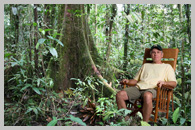
Costa Rica 10 Day Tour - Jan. 25, 2006 |
|
| Costa Rica Photos Web Site -
My Complete Original Coata Rica Photo Web site. I built it to share my photos with all the people on my trip that ask for copies of my photos. Hundreds of photos from the 10 day trip. |
 |
|
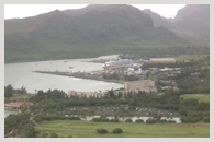
Kauai - Dec. 13, 2007 |
|
| Photos Comming Soon | 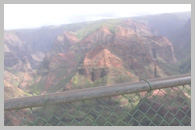 |
| Photos Comming Soon | 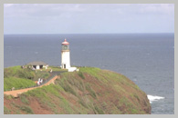 |
|
Kauai Helicopter Ride- Photos Comming Soon
Live Movie - Video of my helicopter tour over the entire island. Views of the Napali Coast. |
 |
|
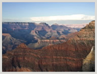
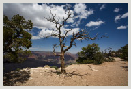
Grand Canyon - May 24, 2011 |
|
| Grand Canyon Day One - Photos Comming Soon
Photos of the changing light in the canyon. Shot from the south rim shortly after I arrived in the late afternoon until sunset. |
 |
| Grand Canyon Day Two - Photos Comming Soon
Photos of my hike down into the canyon on the South Kaibab Trail. |
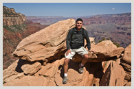 |
| Grand Canyon Day Two - Photos Comming Soon
Photos of my hike along the south rim trying to stay on the edge of the canyon cliffs. |
 |
|
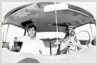
- My Hippie Road Trips 1971 - (40 years ago) |
|
|
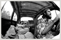
Hippie Trip One - Photos Comming Soon
Slide Show Movie - Photos of the 1st of two trips I took across the country in Spring of 1971 with my friend Neil Fitzpatric in his 1959 Chevy. |
 |
| Hippie Trip Two - Photos Comming Soon
Slide Show Movie - Photos of the 2nd cross country trip taken in the Fall of 1971. This time in my 1961 VW "Bug" with the seat backs replaced with plywood so we could fold them back and sleep in it. |
 |
|
Travel Photos
(Taken with my Canon 5D using L Series lenses) |
|
30 Day Road Trip - Sept. 28, to Oct. 25, 2011 |
|
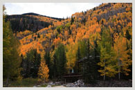
| Vail Colorado -
Photos of the aspen trees changing colors in Vail. |
 |
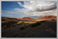
| Storms near Black Dragon Canyon in western Utah -
Photos of some of the big thunder storms I just missed driving across Utah, and of the rocks rising up at 45 degree angles form the ground. |
 |
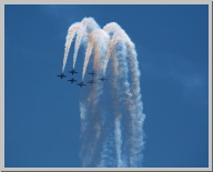
| Angel Island Hike
Took a Ferry to Angel Island to watch the San Francisco Air Show. |
 |
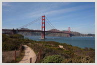
| San Francisco & Gregg's home in Orinda CA
Gregg took a week off from work, and he took me on a tour of S.F. and around the hills of Orinda CA where he now lives. It's across the bay from S.F. near U.C. Berkeley. |
 |
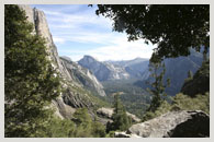
| Yosemite National Park, California -
Photos of my1st day entering the park, with day hikes in the valley & 2nd day when I took an unplanned 8 hour hike 2,700' up to upper Yosemite Falls. I ran out of food & water on the way to the top. Very scary! |
 |
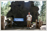
| Sequoia National Park, California-
Drive from Yosemite and into the Giant Sequoia trees. My hike on the Big Trees Trail, and my drive out. I only spent one day there, but it was worth the drive. |
 |
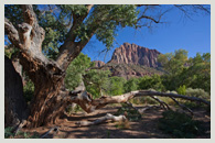
| Zion Canyon National Park , Utah -
Two days in Zions canyon National Park. Shots of the river hike, and a hike around my campsite. |
 |
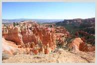
| Bryce Canyon National Park, Utah -
Photos of the Hoodoos from the tourist sections of Bryce. The trails here are wider and safer than the backcountry trails, but have more views of hoodoos. I hiked the Queens Garden & Navajo Loop Trals. |
 |
| Grand Canyon North Rim , Arizona -
Photos of the North Rim of the Grand Canyon. Only one road in and not as many visit due to the long drive to get there. I spent two days in late October and the fall colors were amazing. |
 |
| HWY 89A, the road from the North Rim to Flagstaff -
This long lonely road crosses through miles and miles of Navajo country. Barren rolling plains, with high rock cliffs in the distance. A bleak landscape, but in a strange way still really beautiful. |
 |